

Preview
Faculty Mentor
Christopher Badurek (Geography), Steven Broyles (Biology)
Creation Date
5-2020
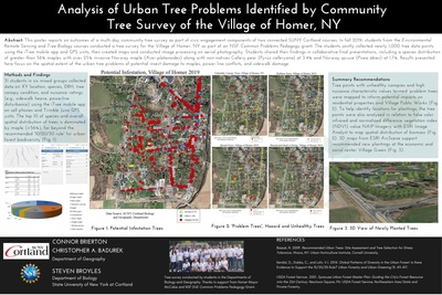
Description
This poster reports on outcomes of a multi-day community tree survey as part of civic engagement components of two connected SUNY Cortland courses. In fall 2019, students from the Environmental Remote Sensing and Tree Biology courses conducted a tree survey for the Village of Homer, NY as part of an NSF Common Problems Pedagogy grant. The students jointly collected nearly 1,000 tree data points using the iTree mobile app and GPS units, then created maps and conducted image processing on aerial photography. Students shared their findings in collaborative final presentations, including a species distribution of greater than 56% maples with over 25% invasive Norway maple (Acer platanoides) along with non-natives Callery pear (Pyrus calleryana) at 3.4% and Norway spruce (Picea abies) at 1.7%. Results presented here focus on the spatial extent of the urban tree problems of potential insect damage to maples, power line conflicts, and sidewalk damage.
Keywords
GIS, Trees, surveys, iTree, aerial photography, urban tree problems, maps, Transformations