

Preview
Faculty Mentor
Christopher Badurek
Creation Date
4-2023
Description
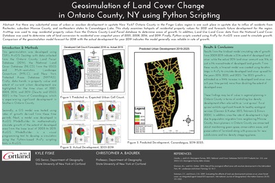
Are there any substantial areas of urban or exurban development in upstate New York? Ontario County in the Finger Lakes region is one such place in upstate due to influx of residents from Rochester, suburban Monroe County, and northeastern states to Canandaigua Lake. This study examines hotspots of residential property values for 2021 and forecasts future development for the region. ArcMap was used to map residential property values from the Ontario County Land Parcel database to determine areas of growth. In addition, Land Use Land Cover data from the National Land Cover Database (NLCD) was used to determine rate of land conversion to developed over snapshot years of 2001, 2008, 2016, and 2019. Finally, Python scripts created using ArcPy for ArcGIS were used to simulate growth. Comparison of the geosimulation model forecast for 2018 with the actual development for year 2019 indicates the model generally was reliable in rate of growth.
Keywords
GIS, Ontario County New York, population growth, human migration, Transformations, Python, National Land Cover Database (NLCD)