


Title
Land Cover Classification of Ice Jam Flooding Using UAS Imagery and Open Source GIS In Plymouth, NH
Preview
Faculty Mentor
Christopher Badurek
Creation Date
4-2022
Description
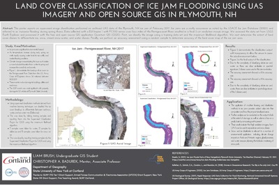
This poster reports on supervised image classification performed on archived UAS data of the Plymouth, NH ice jam of February 2017. Ice jams are a costly occurrence as noted by the USACE Ice Jam Database (2020) and referred to as ‘nuisance flooding’ during spring thaws. Data collected with a DJI Inspire 1 with FC550 sensor over four miles of the Pemigewasset River resulted in a final 3 cm resolution mosaic image. We accessed the data set from USGS Earth Explorer and processed it with the free and open source GIS application Quantum GIS (QGIS). First, we classify the image using a training data set and the maximum likelihood algorithm. We next determine the extent of land cover classes to differentiate ice, snow, mixed snow-water, and water classes. Finally, we perform an accuracy assessment using a random sample to determine accuracy of the land cover map of the ice jam area.
Keywords
Ice Jams, supervised image classification, Pemigewasset River, QGIS, Transformations