


Preview
Faculty Mentor
Christopher Badurek
Creation Date
4-28-2021
Description
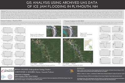
This poster reports on GIS analysis performed on archived UAS data of the Plymouth, NH ice jam of February 2017. Ice jams are a costly occurrence throughout the northern CONUS as noted by the USACE Ice Jam Database (2020). Media Wing Airshark collected the imagery data under contract with the USGS National UAS Program Office (2017) and rapidly processed it for delivery the day following the flight. Data collected with a DJI Inspire 1 with FC550 sensor for image collection over four miles of the Pemigewasset River resulted in a final 3 cm resolution mosaic image of the ice jam impacted area. We accessed the data set from USGS Earth Explorer and processed it with ArcGIS and Pix4D. First, we examined the aerial mosaic of the ice flow in relation to prior high resolution aerial photos. We compare DEMs derived from the aerial imagery with 1 meter resolution USGS DEMs of the area at ten transect locations located along the river. We also compare the image mosaic with FEMA National Flood Hazard to assess spatial extent of the ice jam flooding in relation to expected flood extents. GIS analysis of the UAS data at transects illustrate the extent of the ice jam and demonstrate utility of rapid data collection with UAS for flood response.
Keywords
Pemigewasset River, ice jam, flooding, GIS