

Preview
Faculty Mentor
Christopher Badurek
Creation Date
4-25-2021
Description
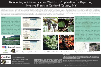
This poster reports on development of a web GIS application for reporting invasive species conducted in conjunction with the iMap Invasives team of the NY Natural Heritage Program. The application was developed using ESRI’s Story Maps application builder and the NY iMap Invasives and NY Protected Areas Database (NYPAD) web mapping services (WMS) used for citizen science. This application provides citizens information about invasive terrestrial plant species targeted for data collection by the NY Natural Heritage Program, including hemlock woolly adelgid, porcelain berry, and oriental bittersweet. Citizen scientists can then identify locations and upload photos using the iMap Invasives mobile app. As part of this project, students in the GPS Technology course were also trained by the SUNY Cortland team on using iMap Invasives for data collection and for conducting data analysis on downloaded invasives data for the SUNY Cortland campus
Keywords
Invasive plants, GIS, iMap Invasives, New York Heritage, New York Protected Areas Database (NYPAD), New York Natural Heritage Program, Web Mapping Service (WMS)